GPS & DGPS
Emitech Infosystems is leading provider of precision measuring instruments. The company is promoted by pioneers in the field of Surveying instruments, Laser instruments, GIS & GPS equipment and other high precision systems. Emitech Infosystems diverse product line provides complete measurement solutions for surveying, mapping and GIS, industrial measurement and construction applications. Our services have been used to complete major projects. Our services are very reliable, accurate and work years together. We have a team of trained engineers to provide efficient and prompt after-sales-service to our customers.
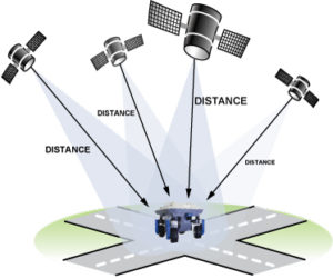 The Global Positioning System (GPS), also known as Navstar, is a global navigation satellite system (GNSS) that provides location and time information in all weather conditions, anywhere on or near the Earth where there is an unobstructed line of sight to four or more GPS satellites. The GPS system operates independently of any telephonic or internet reception, though these technologies can enhance the usefulness of the GPS positioning information. The GPS system provides critical positioning capabilities to military, civil, and commercial users around the world. The United States government created the system, maintains it, and makes it freely accessible to anyone with a GPS receiver.
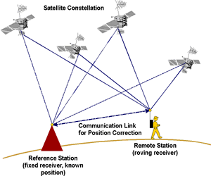
Differential Global Positioning System (DGPS) is an enhancement to Global Positioning System that provides improved location accuracy, from the 15-meter nominal GPS accuracy to about 10 cm in case of the best implementations.
DGPS uses a network of fixed, ground-based reference stations to broadcast the difference between the positions indicated by the GPS satellite systems and the known fixed positions. These stations broadcast the difference between the measured satellite pseudoranges and actual (internally computed) pseudoranges, and receiver stations may correct their pseudoranges by the same amount. The digital correction signal is typically broadcast locally over ground-based transmitters of shorter range.
TOPOGRAPHICAL SURVEY
Detailed topographical survey of a mining site is necessary to understand the physical and geological condition of the land. We conduct topographical surveys for multiple surface features including drainage, hills, barren land, water bodies, roads, bridges, forest pillars, afforested area, dump area etc. This data can be used for getting a visual idea about land use and land cover, generating contour maps etc. Based on this, mining authorities can take crucial decisions for executing various operations.
We have conducted topographical surveys of various surface features at multiple bauxite mines of different mining Industries. These features include scarp face, surface infrastructure, surface drainage, waterbodies, roads, bridges, culverts, village houses, government buildings, temples, power and telephone lines, forest boundaries, mine boundary, lease boundary, pit boundary, mined out area with existing bench position, reclaimed, afforested and dump areas etc. The purpose of this survey was to update and georeference the existing toposheets of the area of interest.
DRONE SURVEY
An unmanned aerial vehicle (UAV), commonly known as a drone, as an unmanned aircraft system (UAS), or by several other names, is an aircraft without a human pilot aboard. The flight of UAVs may operate with various degrees of autonomy; either under remote control by a human operator, or fly autonomously based on pre-programmed flight plans.
We have partnered with a professional agency in India, specialized in UAV / Drone Survey data capture and processing to produce a ground accuracy upto 5 cm in horizontal and vertical. This technology can be used to supplement the Mobile LiDAR data output in case of urban mapping projects, or highways projects having proposed bypass roads. This is also ideal for carrying out Topographic Survey of any land where speed and accuracy is of priority, with the rates comparable to primitive Electronic Total Station (ETS) method of survey.